


PRODUCT
HOME>PRODUCT>nctech>iSTAR Pulsar+

compact mobile mapping system

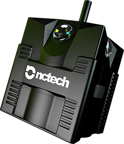
iSTAR Pulsar+ compact mobile mapping system builds on
the success of the groundbreaking iSTAR Pulsar,
providing industry-leading 11K Panoramic imaging in an
accessible form. This flagship solution adds a number of
significant new features that give the user total data
control from capture to delivery.
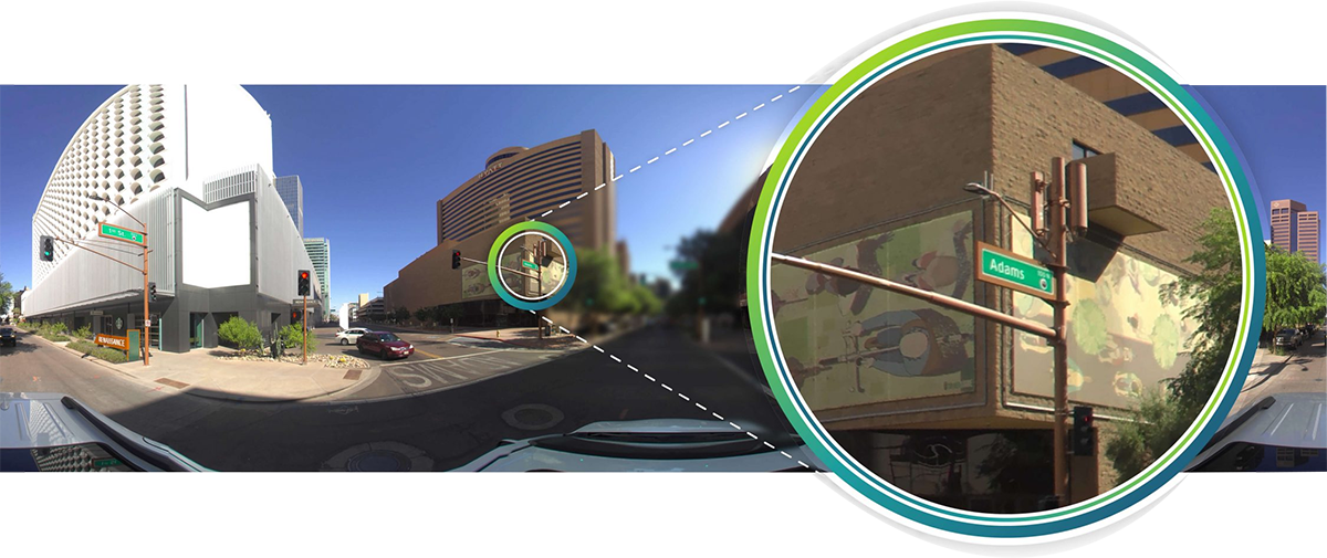
Geo-referenced Image output
The JPG file format embeds GPS coordinates and orientation within every image, ensuring effortless, automatic image positioning within GIS and other location-based processing applications. Corresponding frame positioning file, enables accurate image positioning within alternative workflows, expanding the potential for compatibility. Advanced users benefit from access to raw IMU and GPS records for custom data processing.
Local processing
Copy iSTAR pulsar+ encrypted data via USB into Immersive Studio for local batch processing, bypassing cloud dependency and ensuring total data control from capture to delivery. Featuring an Intuitive UI and our most advanced stitching algorithms, Immersive Studio outputs the highest quality panoramic imagery with zero manual processing.
NCTech SDK
Harness the power of Immersive Studio within
existing workflows and applications. Integrating
the NCTech Immersive Studio SDK guarantees the
highest levels of data portability, ensuring
streamlined processing of iSTAR Pulsar+ RAW
output directly within your own solutions.
Enabling Integration
iSTAR Pulsar+ allows for post-processed
accurate time synchronisation with external
GPS and IMU sensors to provide the highest
level of positional accuracy, adding further
value to existing hardware without physical
connectivity constraints.
Key applications and market sectors
Asset documentation
Road condition surveys
High resolution output imagery allows road conditions to be assessed, i.e potholes, Cracks. Geotagged imagery gives approximate locations of problem areas. iSTAR Pulsar+ 7fps capture rate ensures consistent data density at highway speeds.
Waterways documentation
The ruggedized, IP64 rated exterior of the device ensures confidence for use on waterways, where infrastructure conditions can be documented.
Railway documentation
Visual documentation of rail networks, improving maintenance efficiency. Rugged and robust mounting options offer users a flexible solution to suit their operational preferences.
Construction and disaster response
Construction progress documentation
Increase documentation efficiency by monitoring the construction progress of sites of any scale, inside and out.
Disaster response documentation
Document the effects of disasters for identifying the most damaged areas for targeted investment of resources. Use captured data for improving best practice in relief efforts.
Integrated solutions and machine learning
Integrated solutions
Integration into our solution allows for the capabilities of the iSTAR Pulsar+ to be utilised and enhanced for specialised use-cases. iSTAR Pulsar+ allows automated synch with external devices such as GPS, IMU and LiDAR to provide the highest level of positional accuracy.
Machine learning and AI
High resolution output imagery enables ML/AI tools for uses in advanced fields like smart cities, autonomous vehicle learning, intelligent capture and automated asset management.
High resolution output
The impressive 60.5MP 360 degree output from iSTAR Pulsar+ resolves huge levels of detail in every captured image, perfect for feature interrogation and object detection applications.
Under the hood
Dimensions
Width 118mm
Height 118mm(191mm width antenna)
Width 118mm
Height 118mm(191mm width antenna)
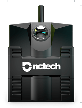
Front
Bottom
Features
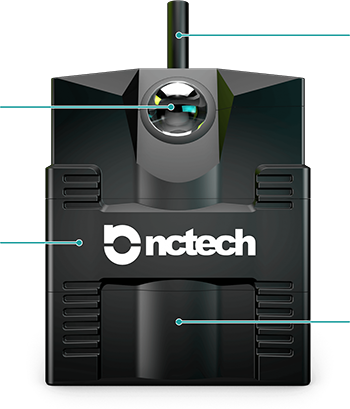
1
2
3
4
Front
1Integrated IMUand GPS sensors
260.5 MP
(11000 x 5500px — 2:1 ratio)
3Ruggedised alloy housing
4Internal SSD
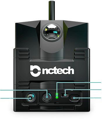
1
2
3
4
5
Back
1Power button
212v DC power socket
3LED status indicators
4Mode selector switch
5USB-C Data transfer port
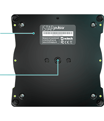
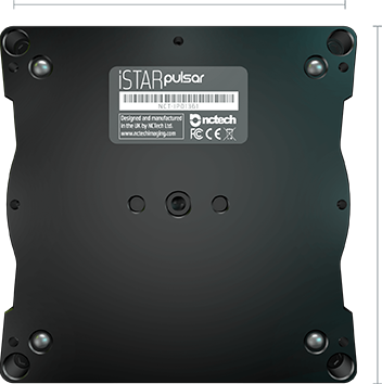
1
2
Bottom
13/8 inch threaded mount hole
2Serial number
M4 Mount holes
(7 holes in total)
Features
| Dimensions | 118 x 118 x 143mm (191mm with antenna) | Weight | 2.1Kg |
| 360 Resolution | 60.5MP (11000 x 5500px - 2:1 ratio) | Storage | 256GB - 1TB SSD |
| System | Extended OSC API | Image Recording Format | .onctd Proprietary Encrypted File Format |
| Output File Formats | .mp4, .png, .jpg, .csv, .txt | Frame Rate | Up to 7fps |
| Sensor | 4 x Sony Exmor RS | Sensor Size | 4 x 12.3MP (3042 x 4062) |
| Lens | 4 x f/2.6 fisheye lenses | FOV | 360 x 145 +/- 5deg |
| Power | 12v DC | Wireless Connectivity | 802.11 b/g/n/ac (2T2R) |
| GPS | U-BLOX Neo M8N (up to 3 GNSS) | GPS Antenna | Multi GNSS Helicore |
| IMU | 6-axis | Magnetometer | 3-axis |
| CPUs | 2 x Apollo Lake | Casing | CNC Hard Anodised Aluminium |
| IP Rating | IP64 | Regulatory Compliance | CE, FCC, RoHS |
| Operating Temperature | 0 - 50 Celsius | Shipping Box Size and Weight |
33 x 21 x 26cm - 3.6Kg |
Learn More

iStarPulsarPlus-brochure